Academia.edu no longer supports Internet Explorer.
To browse Academia.edu and the wider internet faster and more securely, please take a few seconds to upgrade your browser.
…
1 file
Modern Age Fortifications of the Western Mediterranean Coast. Se distribuye bajo una licencia de Creative Commons Reconocimiento-NoComercial-SinObraDerivada 4.0 Internacional. Basada en una obra en http://ocs.editorial.upv.es/index.php/FORTMED V Defensive Architecture of the Mediterranean. XV to XVIII centuries / Vol II / Rodríguez-Navarro (Ed.


![El ingeniero Bautista Antonelli’ en calidad de técnico realizo por lo menos tres viajes a América’ y se sabe que para 1586 habia visitado la ciudad de Panama. Como resultado de esta visita se tiene el tan mencionado plano ‘Planta y perspectiva de la ciudad de Panama’ (figura 2) que se encuentra en la Biblioteca del Museo Naval de Madrid, Espana [signatura 0013 D_0017]. Fig. 2- ‘Planta y perspectiva de la ciudad de Panama’ (1586).](https://figures.academia-assets.com/49872660/figure_020.jpg)


![época (Hardoy, 1991: 97).Este mapa pasa desapercibido y es muy poco utilizado o citado, probablemente porque carece de veracidad o exactitud. Lo que llama la atencién es que el dibujo menciona dos edificios: un cuartel de soldados y las Casas Reales. Asimismo, marca en el sitio unos cafones para defensa del puerto. Al parecer, en 1636 hubo un intento de derribar las Casas Reales debido a su mal estado para construirlas de nuevo, acuerdo al que se opusieron algunos de los oficiales reales que no tenian aposento en este edificio (Panama, 35: N.22). La Corona solicita informes e incluso intenta incluir un nuevo arancel para sufragar los gastos del edificio (Panama, 229: L.3, F.131V- 132R, F.137V-138R). De 1641 existe una propuesta de Antonio Fonseca que se encuentra en el Archivo General de Indias [MP-Panama, 284A y B], pero se sabe que no se llevo a cabo porque no hay rastro de un edificio de esa envergadura en el sitio. Finalmente, en 1646 se sabe que derribaron las Casas Reales sin permiso del Rey (Panama, 229: L.3, F.251R-252R). Fig. 6- Mapa de Panama por Nicolas de Cardona (1632). A pesar de la importancia de Panama como punto de trafico entre América y Espafia, desde finales del siglo XVI y durante todo el siglo XVII, se hace latente en el problema de la falta de defensa de la ciudad. Como se ha mencionado, desde 1532 se propone hacer una fortaleza en la ciudad. Las unicas edificaciones que servian para este fin eran el fortin de la Natividad y las Casas Reales, construccién que todavia estaba edificada de madera. Esto hacia completamente vulnerable a Panama para un ataque pirata, que no tarddé en llegar. Henry Morgan llegé a la ciudad en enero de 1671, luego de atacar el fuerte de San Lorenzo en el](https://figures.academia-assets.com/49872660/figure_024.jpg)


![Fig. 7- Western Front: historical phases, original scale 1:100 ravelin, as well as the circular structure inside There is also the report of another Venetian spy who, in 1684, twenty years after the previous one, provides an accurate description of the fortress, should the Republic decide to conquer it again’. The ortress is described as a “large redoubt”, with no fortification or defence whatsoever; description o the report goes on with the the enclosure — “a simple wall with no terreplein” — the two gates — “with no palisade or guards; one on the tramontane front almost bathed by the river entering the Lake [...]. The other is towards sirocco on the mainland” — and the river. There is no reference whatsoever to the towers at the corners, whereas all the other nearby towers are carefully described. After almost a century, an important description](https://figures.academia-assets.com/49872660/figure_038.jpg)


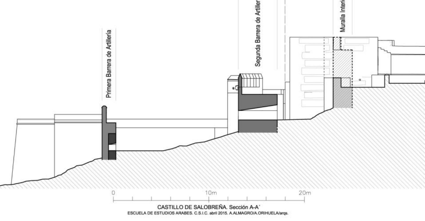
![fortress by sea. As it was such a long distance it would [not] be possible to go forward and assist without doing this, because there are 480 paces from the doorway to the sea The majority of the works planned in 1490 were carried out, although they may have been over different stages of construction covering several decades. The most significant one was the construction of an artillery barrier in front of the Islamic walls on the south-eastern side with less steep slopes, with a round turret in the centre. of brick in some parts. The vaults of the towers,](https://figures.academia-assets.com/49872660/figure_238.jpg)


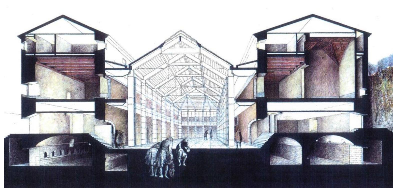
![Fig. 9- Step della ricomposizione del livello inferiore degli ambienti nel modello generale Questa operazione, necessaria in fase di acquisizione per scomporre il problema in complessita piu facilmente gestibili, é servita anche a semplificare la successiva fase di elaborazione dei dati acquisiti. Nella pratica tradizionale da elaborati di tipo bidimensionale, (planimetrie e sezioni) vengono costruiti modelli tridimensionali nei quali le informazioni, per questioni logistiche legate alla gestione del dato, vengono decisamente ridotte e semplificate all’essenziale dell’ingombro volumetrico, a scapito, pero, di tutti quei dati relativi alla composizione superficiale dei singoli paramenti. Una prima macro divisione ha scomposto Voggetto su due livelli, uno inferiore e uno superiore. Il piano inferiore, che presenta numerosi ambienti indipendenti e concatenati, ha previsto un’ ulteriore discretizzazione della struttura classificando ogni rudere, stanza o paramento murario con schemi grafici e codici identificativi. Le caratteristiche di ogni ambiente sono state dapprima esplicate attraverso il disegno: il disegno, oltre a evidenziare le qualita spaziali di ciascun ambiente, ha consentito di analizzare le criticita della struttura e fornire da base per la scomposizione del sistema generale in unita murarie. A seguito di questo processo é stato possibile catalogare ciascun elemento con codici identificativi che permettessero una programmazione ordinata della campagna fotografica. Parallelamente alla realizzazione del rilievo topografico, la campagna fotografica sviluppata per coprire interamente l’oggetto sviluppata per coprire interamente l’oggetto contesto tridimensionale reality based, altamente descrittivo e non discretizzato, avviene una sostanziale semplificazione dei dati acquisiti. La finalita di tale modello é la fruizione via web, la virtualizzazione del sistema che, pertanto, Per il rilievo del forte del San Lorenzo é stato sviluppato un processo inverso. Il modello realizzato € composto da due sistemi perché duplice ne é la finalita. I] primo sistema riguarda il modello completo dell’intero forte, dove dal](https://figures.academia-assets.com/49872660/figure_251.jpg)


![eee ETS Finally, analogous respectful conservation and careful control of the language characterize the interventions on the ruins of the medieval Tower of the Ziro (XV cent.) situated in front of Amalfi. In a monument that has become a ruin, its collapse often makes intemal paths impracticable and the following of an itinerary undoubtedly represents «the minimum condition for use» (Bellini, 1990). The intervention carried out with limited financial resources has seen, alongside accurate and calibrated interventions of material conservation, the insertion of a new staircase with a bolted structure — therefore reversible — which consolidates and clamps the ancient walls of the tower finding space between the still integral parts of vaults and attics, in their turn covered with chestnut shafts, varnished white. Here the contrast of the cause of deterioration accompanied by the alleviation of the effects through defence, favours the use of the tower and, in the end, its conservation. [AU]](https://figures.academia-assets.com/49872660/figure_297.jpg)


Proceedings of the International Conference on Modern Age Fortifications of the Western Mediterranean coast. October 15th, 16th and 17th 2015, at the Ciudad Politécnica de la Innovación, of the Universitat Politècnica de València (UPV). The conference’s main objective is the exchange of knowledge and sharing for the better understanding, assessment, management and exploitation of culture and heritage that developed on the Mediterranean coast in the modern age, taking into account the wide distribution of these results. The Conference has an interdisciplinary aim where architects, engineers, archaeologists, historians, geographers, cartographers, heritage managers, tourism experts, experts in restoration-conservation and promotion of heritage will participate. The idea is to provide a more inclusive, more real and more up to date views, leading us to the point where we could find the investigations of this matter, in the twenty-first century. The theme is centered on the fortifications of the western Mediterranean (Spain, France, Italy, Malta, Tunisia, Algeria and Morocco) in the fifteenth to eighteenth centuries, although it does not exclude other Mediterranean countries and other fortifications from this era.
Proceedings of the Fortmed 2016. Volume 3 FORTMED 2016 is the International Conference on Modern Age Fortifications of the Mediterranean coast. This was the second edition following the first opening in Valencia in October 2015. The conference took place on November 10th, 11th and 12th 2016, at the Dipartimento di Architettura (DiDA) of the Florence University (UNIFI). The conference’s main objective is the exchange of knowledge and sharing for the better understanding, assessment, management and exploitation of culture and heritage that developed on the Mediterranean coast in the modern age, taking into account the wide distribution of these results. The Conference has an interdisciplinary aim where architects, engineers, archaeologists, historians, geographers, geologists, cartographers, heritage managers, tourism experts, experts in restoration-conservation and promotion of heritage will participate. The idea is to provide a more inclusive, more real and more up to date views, leading us to the point where we could find the investigations of this matter, in the twenty-first century. The theme is centered on the fortifications of the western Mediterranean (Spain, France, Italy, Malta, Grece, Albania, Turkey, Cyprus, Tunisia, Algeria, Morocco, etc...) in the fifteenth to eighteenth centuries, although it does not exclude other countries and other fortifications from this era.
The International Archives of the Photogrammetry, Remote Sensing and Spatial Information Sciences, 2017
The Islamic Nasrid kingdom of Granada occupied the mountainous areas of the southeastern area of the Iberian Peninsula. There, a natural border was established between the Nasrid kingdom and the Christian kingdom of Castile from 1232 to 1492. To control this frontier and establish visual communication between it and the Nasrid center at the Alhambra citadel, an extensive network of watchtowers and defensive towers was constructed. Studies have been done of individual towers, but no comparative study has been undertaken of all of them. Graphic, homogenous, and exhaustively planimetric documentation would bring together existing information on the majority of them and enable comparative analysis. For this reason, this work conducts systematic architectural surveys of all these military structures, using photogrammetry. In addition to studying the construction typology and techniques, the structural capacity of these towers has been analyzed. It examines how they have been affected by human and natural destructive forces, especially earthquakes, which are common in eastern Andalusia. Although all the historical military architecture is protected by the Spanish and Andalusian Heritage laws, many of these medieval towers and their cultural landscapes are in severe risk. The towers are being studied as individual specimens (emphasizing their differences) and as a unit in a typological group (looking for similarities and unifying characteristics). New technologies for Information and Communication are being used in order to disseminate the results among specialists and to make them available to the general public. Guidelines for restoration projects are also being formulated from the cases analyzed.
Famagusta, Cyprus was at the center of Eastern Mediterranean trade between the 13th to 15th centuries. Europe wanted goods being delivered from the Levant - cloves, cinnamon, and nutmeg as well as commodities such as wheat and cotton. Famagusta, with its natural harbor on the east coast, was the ideal location for this trade as it was centrally located between Asia, Africa, and Europe. The city prospered with an influx of merchants, and this was reflected in the building of numerous churches, palaces, and fortifications to protect the city. The northwest corner of the fortifications, facing inland, was one of the most critical elements in the defensive network of the city. It was here that the Venetians constructed the Martinengo Bastion in the 16th century. The bastion is a significant example of state-of-the-art renaissance military architecture and is one of the few remaining in the Levant. Its low profile and massive construction was built slightly higher than the opposing counterscarp to present a small target to cannons while its arrow shape was designed to prevent areas of shelter at its base and protect the ditch and bastions on either side. Martinengo Bastion, at the beginning of the 21st century, was in stable condition, however, there were critical issues given its age and materials. The first concern was structural as there were significant undercuts in the foundation bedrock, the opening of cracks in several vaults, vegetation growth, and uncontrolled water was causing erosion and deterioration of the soft sandstone and mortar. There were also inappropriate later interventions such as concrete floors and concrete caps on the vertical shafts and stairways. In 2013, the United Nations Development Programme (UNDP) and the Technical Committee for Cultural Heritage, Cyprus (TCCH) with funding from the European Union launched a project to conserve Martinengo Bastion. The team consisted of a bi-communal Cypriot group of professionals and international experts which was led by Fundación Tecnalia. This article will describe the bastion, the conservation philosophy, methodology, and intervention to preserve this unique example of military architecture.
The International Archives of the Photogrammetry, Remote Sensing and Spatial Information Sciences.26th International CIPA Symposium, 2017
The Islamic Nasrid kingdom of Granada occupied the mountainous areas of the southeastern area of the Iberian Peninsula. There, a natural border was established between the Nasrid kingdom and the Christian kingdom of Castile from 1232 to 1492. To control this frontier and establish visual communication between it and the Nasrid center at the Alhambra citadel, an extensive network of watchtowers and defensive towers was constructed. Studies have been done of individual towers, but no comparative study has been undertaken of all of them. Graphic, homogenous, and exhaustively planimetric documentation would bring together existing information on the majority of them and enable comparative analysis. For this reason, this work conducts systematic architectural surveys of all these military structures, using photogrammetry. In addition to studying the construction typology and techniques, the structural capacity of these towers has been analyzed. It examines how they have been affected by human and natural destructive forces, especially earthquakes, which are common in eastern Andalusia. Although all the historical military architecture is protected by the Spanish and Andalusian Heritage laws, many of these medieval towers and their cultural landscapes are in severe risk. The towers are being studied as individual specimens (emphasizing their differences) and as a unit in a typological group (looking for similarities and unifying characteristics). New technologies for Information and Communication are being used in order to disseminate the results among specialists and to make them available to the general public. Guidelines for restoration projects are also being formulated from the cases analyzed.

Loading Preview
Sorry, preview is currently unavailable. You can download the paper by clicking the button above.
Defensive Architecture of the Mediterranean, 2023
Defensive Architecture of the Mediterranean XV to XVIII centuries - International conference on modern age fortifications of the mediterranean coast, 2017
ISPRS International Journal of Geo-Information, 2023
Antiquity, 2017
DEFENSIVE ARCHITECTURE OF THE MEDITERRANEAN XV to XVIII Centuries - Pablo RODRÍGUEZ-NAVARRO (Ed.), 2015
Defensive Architecture of the Mediterranean. Vol IX, 2018
P. RODRÍGUEZ-NAVARRO (ed.), Defensive Architecture of the Mediterranean XV to XVIII Centuries, International Conference on Modern Age Fortifications of the Western Mediterranean Coast - FORTMED (Valéncia, 15-17 October 2015), Editorial Universitat Politècnica de València, Valéncia 2015, 2015
Journal of Cultural Heritage, 2016
REHAB 2014. Proceedings of the International Conference on Preservation, Maintenance and Rehabilitation of Historical Building and Structures. , 2014
FortMed 2017 Conference proceedings, 2017
Franco Angeli editore, 2019
International Journal of Heritage Architecture: Studies, Repairs and Maintence, 2017
JORGE CORREIA Y ANDRÉ TEIXEIRA, COORDINADORES: THE IBERIAN PENINSULA AND NORTH AFRICA (15th to 17th centuries). History and Heritage, 2019