Bending and unbending of an elastic lithosphere: The Cenozoic history of the Apennine and Dinaride foredeep basinsTectonics, 1994
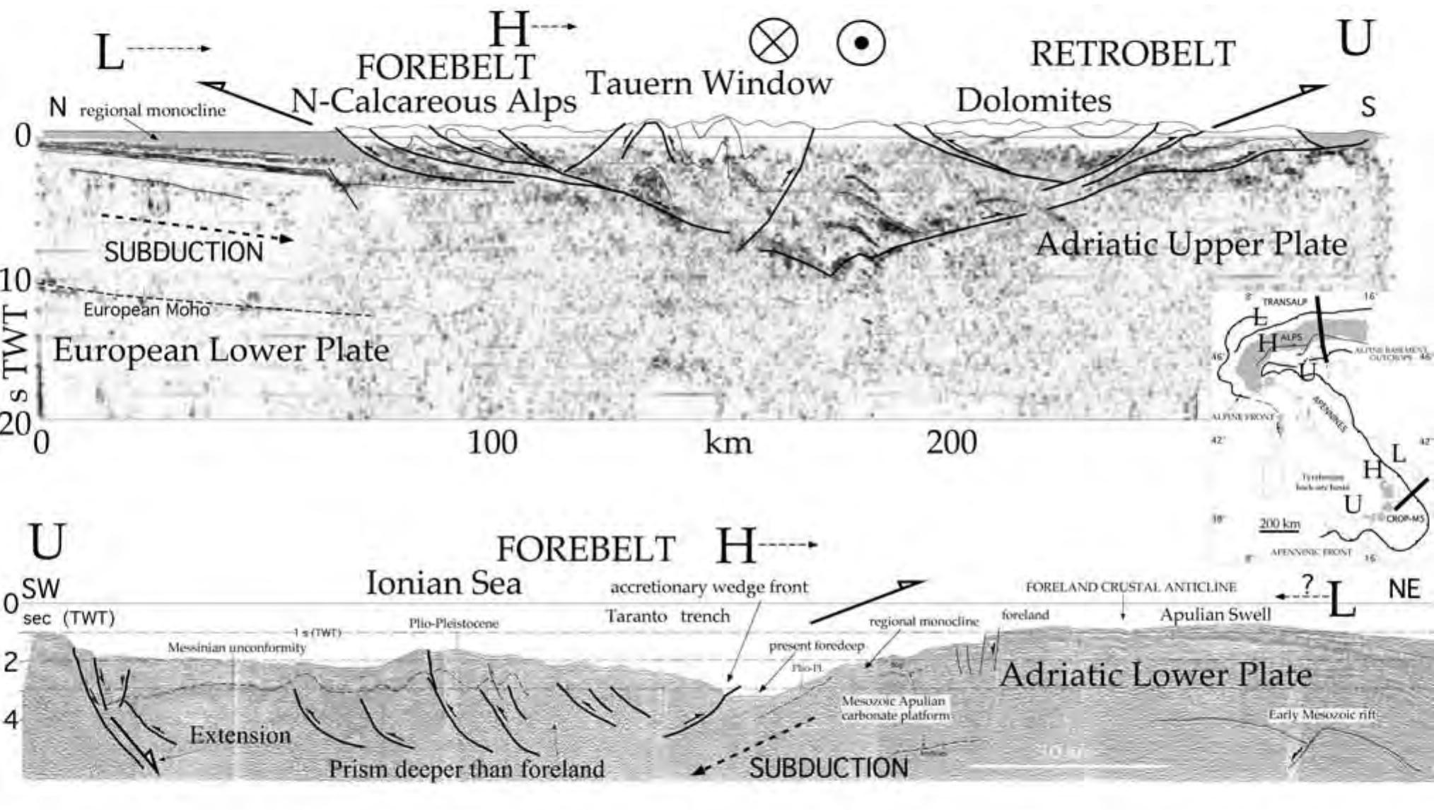
The Adriatic region forms an intermediate continental foreland overthrust along its northeastern margin by the southwest vergent Dinaric thrust belt in Eocene-Oligocene time and along its southwestern margin by the northeast vergent Apennine thrust belt in Pliocene-Quaternary time. Orogenic activity within these thrust belts was accompanied by the development of two superposed foredeep basin systems of opposite polarity and different ages. Using well log, biostratigraphic, and seismostratigraphic data, the geometry of this composite basin system was reconstructed along three profiles at beginning of Quaternary, middle Pliocene, beginning Pliocene, and beginning Eocene time. Modeling of reconstructed geometries using a thin elastic sheet approximation yields a range of acceptable effective elastic plate thicknesses for the central Adriatic region of Te=5-10 km for Eocene-Oligocene flexure and Te= 10-15 km for Pliocene-Quaternary flexure (although an upper bound for Te could not be established on one of the three profiles). These results are consistent with a constant effective elastic plate thickness of Te=10 km for the Adriatic lithosphere and preclude the possibility that significant weakening of the Adriatic plate occurred between flexural events. Modeling of incremental deflections between Pliocene and Quaternary time gives results consistent with constant values of Te=10 km in the central Adriatic and Te=15 km in the northern Adriatic and Po Plain and shows little evidence for weakening of the plate during Pliocene-Quaternary time. Thus within the resolution of the data presented in this paper, there is little evidence for viscous relaxation of the lithosphere on time scales between about 2 and 50 m.y. Analysis of bending of an idealized lithosphere with a simple brittle-elasticductile theology, and a low to moderate thermal gradient suggests that the small values of Te observed within the Adriatic region can be readily understood as the result of bending of the lithosphere to unusually high curvature (4 x l0 -6 m -1) and do not require unusually high temperatures within the foreland lithosphere. The same theological model is also consistent with the absence of significant inelastic Paper number 93TC01935 0278-7407/94/93TC-01935510.00 yielding for at least 50 m.y. after the cessation of loading. An apparent unbending of the Adriatic lithosphere began in early Quaternary time, approximately coeval with the cessation of major thrusting within the Apennine thrust belt. The threedimensional pattern of Quaternary deflection makes it difficult to attribute this phenomenon to local depositional processes and suggests that unbending reflects a fundamental change in the subduction process in early Quaternary time. Our preferred interpretation is that unbending is the result of a diminution of forces acting on the subducted Adriatic lithosphere at mantle depths. The Dinaride and Apennine orogenic belts have formed in response to local accommodation of convergence between the Eurasian and African plates in Cenozoic time. Between these two thrust belts lies an intermediate continental foreland lithosphere, overthrust from the northeast by the Dinaric nappes and from the southwest by the Apennine nappes. This intermediate foreland currently underlies the northern Adriatic Sea and the Po Plain of Italy and is referred to here as the Adriatic lithosphere or Adriatic fragment (many authors also refer to it as Apulia, particularly in discussions of southern Alpine tectonics). The basement of the Adriatic fragment forms a central high and deepens to the northeast and to the southwest toward the opposing thrust belts. The Moho lies at 25-to 35-km depth in the northern Adriatic Sea and deepens to the west [Finetti et al., 1966; Giese and Morelli, 1975; Cermak, 1978]. The foredeep basin along the northeastern side of the Adriatic Sea and the Dinaride thrust belt of Yugoslavia developed contemporaneously with southwest vergent thrusting in the Dinaric Alps in Eocene-Oligocene time. Thrusting involved Mesozoic and Paleozoic sedimentary rocks as well as Cenozoic sedimentary rocks deposited in the internal (northeastern) parts of the foredeep basin. The amount of shortening recorded in the Dinaride thrust belt increases southward, reaching several hundreds of kilometers in the southern Dinarides (for a summary, see Burchfiel [1980]). External to (southwest of) the Dinaric thrust belt, late Cretaceous to early Eocene(?) reefs indicate a shallow marine environment within much of the Dinaric foreland. These carbonate rocks are overlain by Eocene to Miocene clastic deposits that fill the foredeep basin and thicken toward the northeast, reaching a maximum thickness of 5-6 km. Subsidence of the foredeep basin and thrusting within the Dinarides ceased probably by Oligocene time. Eocene to Miocene sedimentary rocks in the foredeep are overlain by Pliocene sedimentary rocks associated with the development of the Apennine foredeep basin. Pliocene development of the Apennine thrust belt and western Adriatic foredeep basin postdates tectonic activity in the Dinarides. Northeast directed thrusting in the Apennine thrust belt occurred throughout Miocene and Pliocene time in response to southwestward subduction of the Adriatic lithosphere beneath the mountain belt [Civetta et al., 1978; Mantovani et al., 1992]. The thrust belt migrated to Southern ps Po Plain D 200 km Tyrhennian Sea 28o Kruse and Royden: Bending of the Adriatic Lithosphere the east throughout middle and late Miocene time, transporting sedimentary rocks originally deposited on the Adriatic plate and stripped from their basement during thrusting [e.g., Ogniben et al., 1975; Bally et al., 1986; Cooper, 1988]. The present Apennine-Po foredeep basin was formed in Pliocene-Quaternary time, but remnants of older foredeep basins can be found within the thrust belt itself [e.g., Patacca and Scandone, 1989]. The present basin thickens uniformly to the southwest, containing up to 8 km of Pliocene-Quaternary sediments [Ogniben et al., 1975; Pieri and Groppi, 1981]. At least 60-170 km of shortening is estimated to have occurred across the central Apennines in Pliocene-Quaternary time [Bally et al., 1986]. Evidence pointing toward significant west dipping subduction of the Adriatic lithosphere beneath the Apennine thrust belt includes palinspastic restorations that show up to several hundred kilometers of shortening across the belt [Bally et al., 1986] and the presence of arc volcanism along the Italian peninsula [Barberi et al., 1974]. A narrow, northwest-dipping Benioff zone exists west of the southernmost portion of the Apennines and the Calabrian arc, with hypocenters to 600-km depth [Gasparini et al., 1982]. West of the Apennine mountains, late Miocene-Pliocene extension within the overriding plate has Publ., 414, 1-13, 1981. Royden, L., Flexural behavior of the continental lithosphere in Italy: Constraints imposed by gravity and deflection data, J. Geophys. Res., 93, 7747-7766, 1988. Royden, L., E. Patacca, and P. Scandone, Segmentation and configuration of subducted lithosphere in Italy: An important control on thrust belt and foredeep basin evolution, Geology, 15, 714-717, 1987. Royden, L. H.,The tectonic expression of slab pull at continental convergent boundaries, Tectonics, 12, 303-325, 1993. Ruggieri, G., D. Rio, and R. Sprovieri, Remarks on the chronostratigraphic classification of lower Pleistocene, Boll. Soc. Geol. Ital., 103, 251-259, 1984. Sclater, J. G., and P. A. F. Christie, Continental stretching: An explanation of the post-mid-Cretaceous subsidence of the central North Sea basin, J. Geophys. Res., 85, 3711-3739, 1980.
 Carlo Doglioni


![Fig. 9 - Generic Mohr diagram showing a composite Griffith- Coulomb failure envelope for intact rocks. The three shown cri- tical stress circles represent different failure modes: tensional fracturing, transitional-tensional fracturing (also called in lite- rature extensional-shear fracturing) and compressional failure (also called in literature compressional shear failure). Fig. 8 - Mohr diagram showing the state of effective stress at failure for various experiments (varying the confining and the axial load) with intact Fredrick Diabase. Each circle represents the state of stress at failure at a different mean stress ([o1+02+03]/3). The locus of stress states that bounds the field of stable and unstable stresses is called the Mohr envelo- pe (after Suppe, 1985).](https://figures.academia-assets.com/32635436/figure_011.jpg)


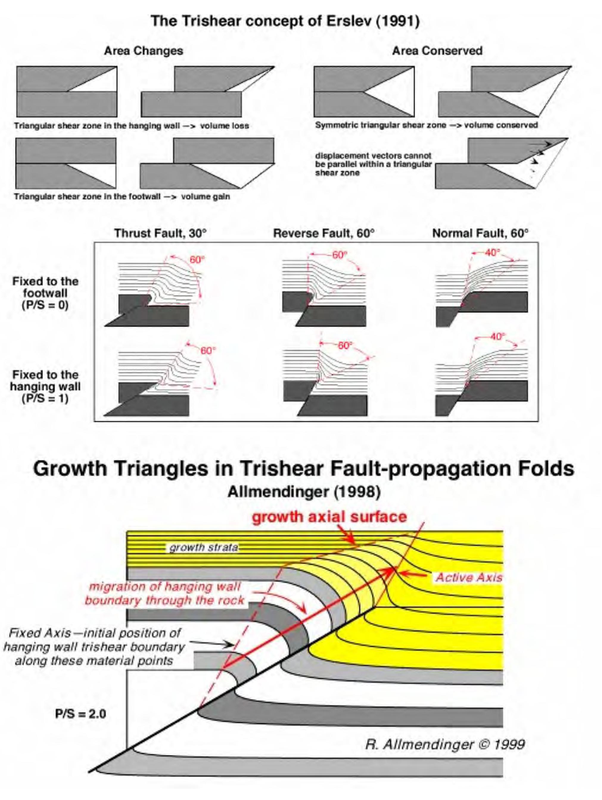
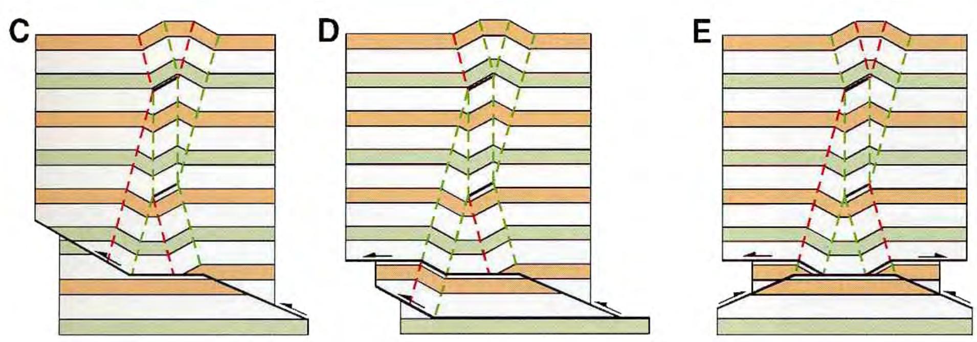
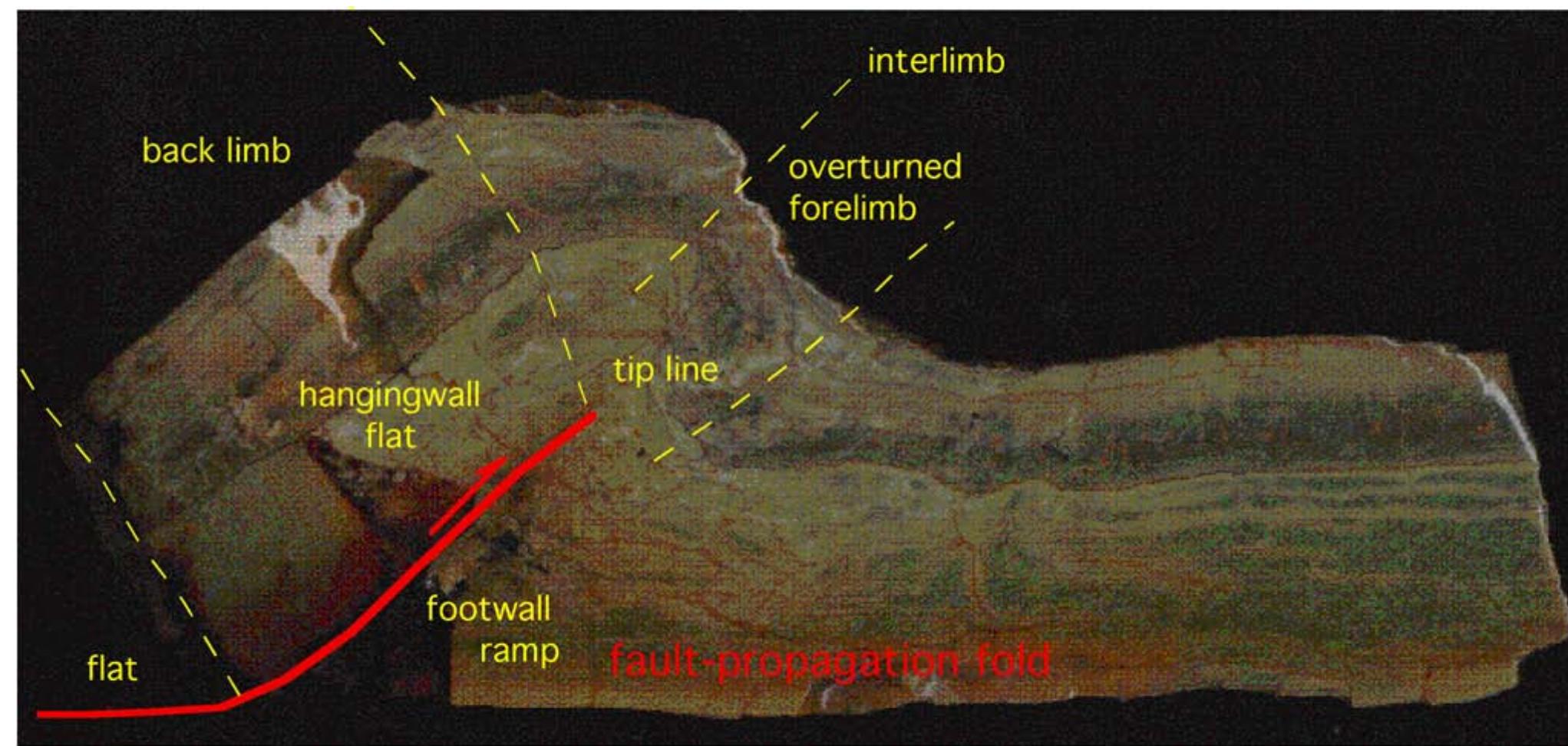
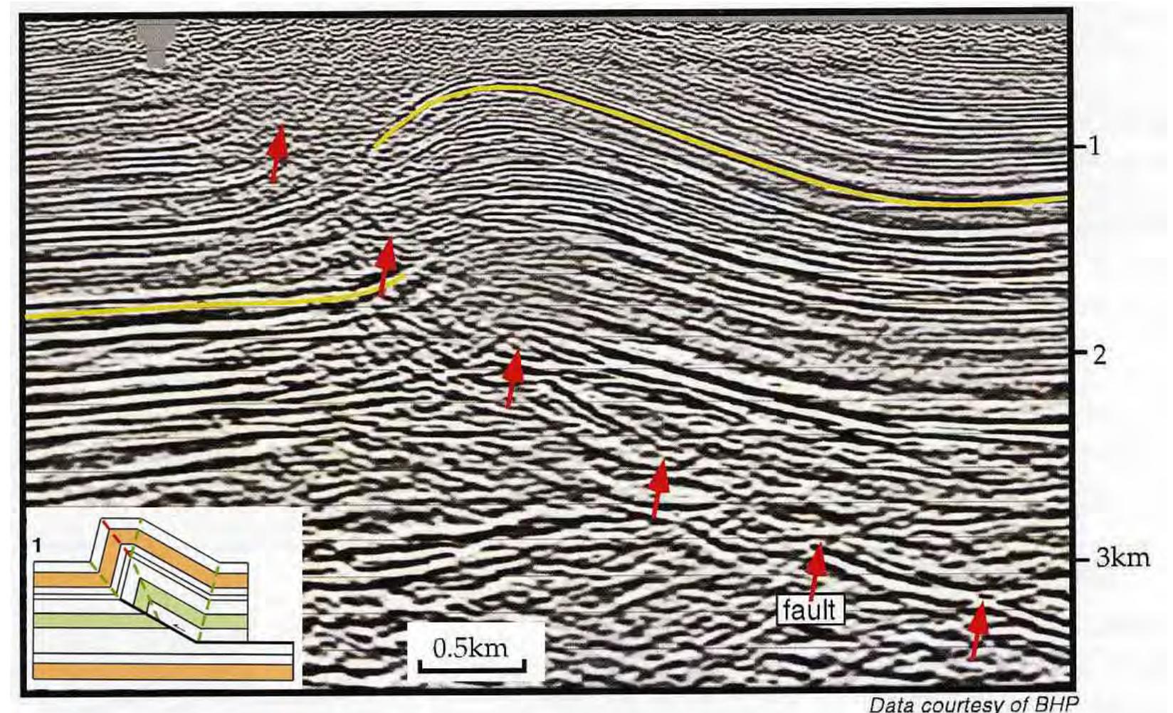
![Fig. 47 - The trishear model (ERSLEV, 1991, ALLMENDINGER, 1998) explains most of the deformation occurring at the tip line of faults. httn://www geo. cornell edu/RWA /trishear/default htm]](https://figures.academia-assets.com/32635436/figure_054.jpg)